How an abundance of water can put people at future risk
Produced by the SUMERNET media-research partnership fund, this article mentions the environmental impacts and potential challenges on the residents of U Minh Thuong’s buffer zone, Kien Giang province, Vietnam.
 By My Le
-
Jun 29, 2022
By My Le
-
Jun 29, 2022

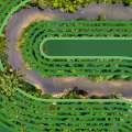
For the residents of U Minh Thuong’s buffer zone, Kien Giang province, Vietnam, it is only a matter of time before a livable wetland is filled with harsh conditions.
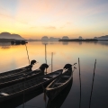
We arrived in U Minh Thuong National Park (UMT) in the middle of the dry season just to find that fresh water was still plentiful in the forest and the canals. Separating fruit orchards was either watery rice fields or ditches - sometimes deep and wide enough for 2 “vỏ lãi” (*) to go back and forth. Moreover, rain was not totally absent for this time of year.
(*) A common type of motor boats in the Mekong Delta.
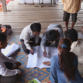
Therefore, it is understandable that most of the farmers did not complain about their water resources during an interview with researchers from the University of Science (Vietnam National University, HCMC) on February 15th. The interview was part of a SUMERNET 4 All project titled “The role of wetlands in water security for the Mekong region” (hereinafter referred to as the Project).
The comfort zone
UMT has a core area of around 8,000 ha, surrounded by a buffer zone of 13,000 ha. While the core zone is strictly protected with a closed system of canals and dikes, the buffer zone is basically agricultural land divided by big channels with the purpose of storing water.
In the 1990s, Kien Giang allowed more than 3,400 households into the buffer zone to develop farming. Today, the number of households has doubled, according to the Statistical Yearbook 2020 of UMT District.
Born and raised in Vinh Thuan - a district next to UMT, Mr. Ly Van Tinh was among the first people to settle in the buffer zone. At the age of 69, he now has a fruitful mango orchard and a neighborhood full of his descendants and relatives along Channel 21, An Minh Bac commune. A common case in local communities: many of the new households are descendants of the first inhabitants. "This region, to be honest, is quite wonderful... there is no competition for water; everyone has decent land (to use)", he said.
Like the majority of households in UMT, Tinh’s family spent money on drilling their own well to get groundwater for cooking, drinking and other essential needs, in addition to the custom of storing rain water. Water in the channels is available all year round for irrigation.
For Mrs. Thi Thuong and her family, living right next to the core zone is more challenging. In 2000, she started a new life with her husband in UMT. However, it was not until January 27th this year that the couple and their four children officially had … electricity to pump groundwater up to use. Before that, they had to use channel water for all activities, except for cooking and drinking.
Yet during the 40-minute conversation, never once did she express any concern about water shortage. “People shut the sluices around here; so fresh water is available all year round, thanks to which I could survive for the last 20 years", she said with delight.
What really bothers her is the fact that "there is land, but the crops always fail". In most cases, the excess water is to blame. “Ginger, taro, cucumbers, etc. - once flooded - will be gone; so will the fishes”, Thuong sighed.
Even though they have to work day and night to pay off the debts, Thuong never thinks of leaving UMT. “Our father gave us this land; we just keep working. Herbs and vegetables grow themselves; we just eat them. Life is easy. There is peace; there is no competition.”
In summary, these days in UMT buffer zone, it seems that water is still sufficient for the rich and the poor. But when it comes to the future, researchers assert that water shortage is unavoidable. They also warn that competition for water has been the cause of many conflicts around the world throughout history.
It all started 20 years ago
The UMT peat swamps are a freshwater wetland ecosystem, although it is located less than 50km from the sea. It is also noteworthy that the Mekong River does not flow through UTM. So where does its abundant fresh water come from? The very answer is rainwater.
Historically, U Minh as a whole (before splitting into present-day U Minh Thuong and U Minh Ha) was a low-lying area, located in a region that receives the highest rainfalls in the Mekong Delta. High rainfall and poor drainage through river channels created prolonged inundation, allowing peat to accumulate. Peat layers act like water sponges, absorbing rainwater during the May-November wet seasons and gradually releasing it during the December-April dry seasons. As a result, the flora and fauna of the forest as well as its “next door” people have fresh water all year round.
However, a catastrophic fire in March and April 2002 had burned about 90 % of the peat area of UMT. In some places, the entire peat layer was burned to the ground. In other ones, the peat thickness was also significantly reduced. The current area of peat swamp is estimated at approximately 3,000 ha (Tran Triet, 2016), a great loss compared to 5 decades ago, which was 12,400 ha documented in 1976 (Vo et al. 2010).
"Unfortunately, the remaining area of the core zone is too small, which means even if it absorbs water to capacity, there is still not enough water for the surrounding communities to use”, said Dr. Duong Van Ni, an expert on Mekong wetlands who leads the Project. "This is the first precariousness that cannot be solved.”
Besides, the potential disadvantageous weather conditions should be taken into account. Climate change is likely to make the temperature rise, hence longer dry seasons, causing the peatland to decompose and thin out. “They think life (in UMT) is very secure, but it isn’t”, Dr. Ni of Can Tho University said.
After the 2002 disaster, UMT National Park knew it would be wiser to prevent fires than to put them out. A system of dikes and sluice gates is responsible for storing water inside the core zone at the end of the wet seasons for forest fire prevention in the dry seasons. In other words, most of UMT core area has turned into permanent water bodies and the water level there is relatively independent of the outer buffer zone.
Dr. Ni concluded: “If there is a limited amount of water, priority will be given to protecting the core region, so that it won’t burn. If the core area burns, the buffer zone will also burn. Thus, the buffer zone will definitely lack water”.
First, we raise awareness
“The biggest threat is that people lose their caution, because everything is normal and they are so overconfident that there is nothing to worry about. Therefore, when changes occur, such as climate change, they will be the most vulnerable group”, Duong Van Ni explained why the Project involved such a seemingly water-secure area.
He compared UMT with Ben Tre province, where there have been several events of freshwater shortage. Ben Tre is, understandably enough, better prepared to face water scarcity in the near future. Meanwhile, in UMT, "the public have no experience, but the local authority is even more inexperienced, and there is no infrastructure needed for clean water supply".
According to IUCN’s “Climate Change Vulnerability Assessment U Minh Thuong” in 2019, “most important climate threats to UMT’s wetlands are severe and prolonged droughts, higher air temperatures, flooding and salinity intrusion due to sea level rise”. In addition, “occurrence of extreme events, such as heat waves, strong storms, and torrential rains, will be more frequent and mostly unpredictable”. Droughts and higher air temperatures will also increase the risks of uncontrollable fires that threaten the existence of the last remnants of peat swamp forests in UMT.
Meanwhile, “local people’s livelihoods are also highly vulnerable to climate adversities”, the authors wrote. “In recent years, UMT area experienced two severe droughts in 2013 and 2015 and a big flood in 2017, which caused substantial losses to local livelihoods”.
“When we talk about water security, the first 'security' is in people's minds… With this project, we don't expect to do anything immediately afterward; we’d like to change how they think (about water), to make them see that they are living in an environment where risks can occur at any time."
Researchers believe that when people are aware of the risks, solutions already exist in indigenous knowledge. At the same time, the local authority is expected to prioritize where to invest. "Now we should stop thinking about preventing saltwater, we’d better think about storing fresh water", Dr. Ni added, "the lessons from other provinces are out there. They won’t need to seek for a solution from any Western countries. They just need to ask the people in Ben Tre, for example”.
By April, Dr. Ni and his team had completed field surveys in the UMT buffer zone. They will use this data to design an interactive game that can engage local people in talking and learning about the inevitable risks of water scarcity.
Together with U Minh Ha National Park (Ca Mau province), UMT is one of the key sites for wetland biodiversity conservation in the Mekong Delta, while preserving the last remnants of peat swamp in Vietnam. It is an Important Bird Area (IBA) of Vietnam, a Ramsar Site and one of the Association for Southeast Asian Nations (ASEAN) Heritage Parks.
--------------------
Produced by the SUMERNET media-research partnership fund, this article highlights the impacts of flooding, excessive rain falls, saltwater intrusion, poor drainage system and potential climate change scenario upon the livelihood of communities in U Minh Thuong’s buffer zone, Kien Giang province, Vietnam.
As part of the work of the SUMERNET media-research partnership fund 2022, a young journalist from Vietnam, Le My, wrote an article. “How an abundance of water can put people at future risk”, by field visits, consultations, and interviews with the local residents of U Minh Thuong buffer zone as well as the researchers from the University of Science (Vietnam National University, HCMC). This article was also published on Voice of Vietnam, online media platform in the Vietnamese language.
Càng bình yên, càng dễ tổn thương (vovgiaothong.vn)
SUMERNET provided eight grants worth up to US$2,800 to 8 journalists in the Mekong Region (Thailand, Vietnam, Cambodia, and Myanmar) for partnership with SUMERNET and affiliated researchers to produce multimedia products on environmental topics in the Mekong Region.
During the partnership (from June 2021- June 2022), young journalists and multimedia producers have delivered different stories, blogs, documentaries on the environmental issues in collaboration with SUMERNET affiliated researchers from the different countries in the Mekong region. Media-research partnership grantees also organized a series of different trainings and sharing sessions for the media capacity development of the researchers.
Info
This story is part of the following project
SUMERNET 4 All: Engaging with water insecurity in the Mekong Region
Topic
Country
Related people


You might be interested in
-
SUMERNET Vision Guide introducing the new phase "SUMERNET 4 All"
The new, revised "Vision Guide" for SUMERNET is now available. This vision guide presents an overview of SUMERNET - its origins and governance structure, background to the network, aims, key research areas, engagement with policy, and outreach products
![SUMERNET Vision Guide introducing the new phase "SUMERNET 4 All"]()
-
SUMERNET 4 All Call for Proposals on Joint Action
SUMERNET 4 All (S4A) provides financial support and technical assistance to consortia of researchers and boundary partners from the Mekong Region
![SUMERNET 4 All Call for Proposals on Joint Action]()
-
SUMERNET launches redesigned website to provide a fresh visual look and direction
SUMERNET is proud to announce the launch of our redesigned website to coincide with our new phase of work on addressing water insecurity in the Mekong Region.
![SUMERNET launches redesigned website to provide a fresh visual look and direction]()
 Read more about SUMERNET
